Ενότητα για τους κατασκευαστές γενικά
Άβαταρ μέλους
By Serf
#193620 Οι έχοντες TypeR (MIXOStsi, mirage, κτλ) μήπως μπορείτε να βοηθήσετε στα σχετικά topics για:
- Φρένα: http://www.petrolheads.gr/viewtopic.php?f=13&t=56&p=192964#p192964
- Αμορτισέρ: http://www.petrolheads.gr/viewtopic.php?f=13&t=55&p=192998#p192998
Άβαταρ μέλους
By MIXOStsi
#227883 Σαν μοντέλο του 2008 που είναι το δικό μου, δεν είχε aux-in και λοιπές ιστορίες. Οπότε κι αγόρασα ενα Yatour με SD, USB, minijack και δυνατότητα να δεχθεί BT με ξεχωριστό module.

Εικόνα

Τι έμαθα απ' το παραπάνω:
Είναι πιο εύκολο απ' ότι φαίνεται.
Το πλαστικό πάνω απ' το headunit, κάτω απ' την κεντρική οθόνη μου έβγαλε τη πίστη για να βγει και τελικά δεν βγήκε. Κατάφερα να το ανασηκώσω απλά...
Στο armrest προυπάρχει τρύπα που κλείνει με rubber grommet και μπορείς να περάσεις καλώδιο.
Το mini ντουλαπάκι μπροστά απ' τον λεβιε/κάτω απ το headunit είναι ανοιχτό από πάνω και μπορείς να περάσεις καλώδιο (εκεί το έβαλα εγώ). Θέλει λίγο φάγωμα το πλαστικό όμως γιατί βρίσκει το καλώδιο και δεν ανοίγει τέρμα όπως πριν.
Ηλίθιος ο τρόπος κατασκευής για να φτάσεις στο headunit. Λύνεις το μισό αυτοκίνητο.
Βρήκα το φίλτρο βενζίνης. Όταν έρθει ο καιρός, θα τους το πάω έτοιμο για άλλαγμα.

Αυτά νομίζω. Το Yatour κάνει ό,τι λέει το κουτί.
Δεν ξέρω αν διαβάζει tags. Μέχρι τώρα τα λέει Track 001 etc.

Αν θέλετε κάτι, ρωτάτε... όπως έκανε ο mirage. :lol:
Άβαταρ μέλους
By Nosferatu
#228964 Yatour εβαλα και εγω στο κορολα. Μια χαρα παιζει, 9 φακελους μεχρι 99 τραγουδια στον καθενα χωρις τιτλο. Μια φορα το μηνα θα φαει ενα σκαλωμα και θα κολλησει σε ενα φακελο. Τοτε πρεπει να του βγαλεις την τροφοδωσια, αρα πρεπει να ειναι προσβασιμο

< Smart ultra 6 >
Άβαταρ μέλους
By REALZEUS
#241272 Καλή πρωταπριλιά και σε σένα...
Άβαταρ μέλους
By JasonLouk
#246557 Hondells "Little Honda" :lol:
Άβαταρ μέλους
By rx8_drifter
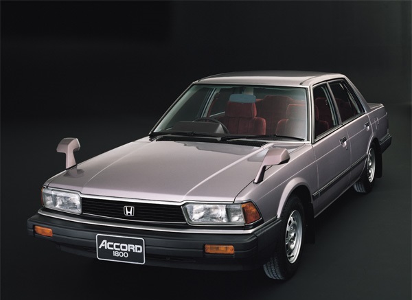
#259509 Έπεσα τυχαία σε μια φωτό του παλιού Accord της οικογένειας και προσπαθούσα να βρώ πληροφορίες μιας και ήταν ειδική έκδοση, αμερικάνικων προδιαγραφών. Χαρακτηριστικά θυμάμαι εν έτη 1982 είχε ηλεκτρική ηλιοροφή, παράθυρα και υπολογιστή ταξιδιού :s_inlove

ήταν ακριβώς έτσι

Εικόνα

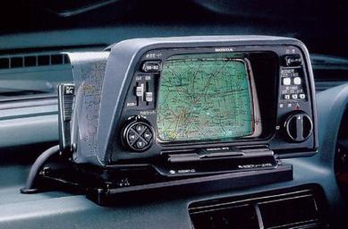
Τεσπά, τα γράφω όλα αυτά γιατί ψάχνοντας για το αμάξι, πέτυχα το εξής ΚΟΥΛΟ αξεσουάρ:

https://en.wikipedia.org/wiki/Electro_Gyrocator

Το πρώτο GPS
Εικόνα


Tρελαμένοι Ιάπωνες :s_crazy :s_crazy :s_wacko
Άβαταρ μέλους
By drdino
#259520 Γαμάτο!

Μου θύμισες αυτό:
Εικόνα
1983

κι αυτό:
Εικόνα
1985 :lol:
Άβαταρ μέλους
By Giuseppe Busso
#259524 Καλά σήμερα είδα ένα Civic hatchback 5ης γενιάς, μπλε μεταλλικό. Σαράβαλο και χιλιοχτυπημένο μεν, γαμάτο αμάξι δε. Κουκλί ήταν. Είχε ο πατέρας μου ένα 1300 λευκό το 1992 νομίζω.

Εικόνα

BTW έψαξα όλη τη Google για να βρω ακαγκούρευτο :dizzy:
Άβαταρ μέλους
By rx8_drifter
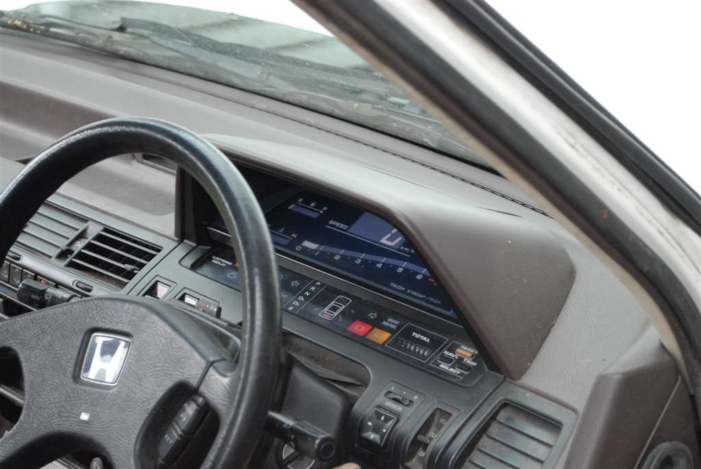
#259532 Mόνο που αυτά ήταν concept, ενώ η χοντάρα

Εικόνα

:s_inlove :s_inlove :s_inlove
http://www.3geez.com/forum/classic-hond ... -dash.html

1985 ρε μλκες, τί έβγαζε αυτή η εταιρία. Το δικό μας το δώσαμε στους γύφτους για σκρπα με 500.000 χλμ δυστυχώς είχε κατασαπίσει :s_cry
Άβαταρ μέλους
By Giuseppe Busso
#259537
rx8_drifter έγραψε:
1985 ρε μλκες, τί έβγαζε αυτή η εταιρία. Το δικό μας το δώσαμε στους γύφτους για σκρπα με 500.000 χλμ δυστυχώς είχε κατασαπίσει :s_cry


Κλασσικό πρόβλημα για Honda, ειδικά στους θόλους.
Άβαταρ μέλους
By rx8_drifter
#259538 Εμάς δυστυχώς έμπαζε νερά απ τα νεύρα της οροφής και το πήραμε αργά χαμπάρι. Του είχαμε κάνει ολικό βάψιμο, αλλά ο μάστορας που έκανε τη δουλειά (υποτίθεται κορυφαίος©) ήταν για πούτσα και καράτε :x Μπορεί να ζούσε ακόμα :s_cry


Ένα πιο αναλυτικό αρθρο για το GPS της Χοντάρας

http://www.carlist.my/news/worlds-first ... cord/17639

The World’s First In-Car Navigation System: Pre-GPS Era, 1981 Honda Accord
NEWS
HANS AUGUST 11, 2015 15:00
Εικόνα
The World’s First In-Car Navigation System: Pre-GPS Era, 1981 Honda Accord


On this month of August, 34 years ago in 1981, the world’s first commercially-available in-car navigation system was introduced in the second-generation Honda Accord and its upmarket twin Honda Vigor.
Remember that the year was 1981. Global Positioning System (GPS) satellites would not be available for civilian use until 1983, and even then, the system was intentionally made less accurate by the US government, limiting its accuracy to only about 100 metres.

The GPS system as we know it today, accurate to about 3 metres – good enough for turn-by-turn directions - is a fairly recent advancement and was opened to civilian use only in 2000.

This was still the era of the cassette-playing Sony Walkman. Electronics were mostly used for analogue signal processing rather than digital. There were no multi-gigabyte flash memory cards, only 1.44 megabytes floppy disks.

Without the necessary network of satellites, digital hardware and high capacity data storage, how then would one go about creating an in-car navigation system?

Simple: the same way how all great engineering feats were achieved in the age of antiquities: by a lot of improvisation.

The Intelligent Automobile – As Envisioned In the ‘70s

In 1976, Katsutoshi Tagami, then an engineer at Honda R&D in-charge of Honda’s power generator products, was summoned by his Senior Managing Director Tadashi Kume, Honda’s superstar engineer who created Honda’s CVCC engine – the first engine to clear tough Clean Air Act emission standards in the US, something which all major car companies including Ford, General Motors and Toyota said cannot be done by the 1970 deadline.

Realising that automotive electronics was fast becoming a crucial part of vehicle development, Kume reasoned that it would be unwise to rely on suppliers for such a crucial part of a car.

“I want you to take charge of electrical equipment for automobiles," Kume told Tagami.

"Your role," Kume explained, "is to bring us up to the level of other manufacturers and eventually get a step ahead of them."

Kume had drafted a rough strategy for which the eventual goal was to create an autonomous Honda car that drivers could input a destination, and have the car drive itself there.


Of course, this was a long shot and such a dream would not be realized until 36 years later, in 2012, ironically not by a car company, but by Google, who even more ironically was using a modified second-generation Toyota Prius (video below).


Kume’s "Automatically Adaptive and Creative Electronically Controlled System" strategy created the foundation for Honda to pursue various research into automotive electronics, which later culminated in the PGM-F1 electronic fuel injection system, cruise control, and later on other digitally controlled ‘by-wire’ systems for the steering, throttle and brakes.

A navigation system was one of the components of this theoretical autonomous Honda car so it was identified as an area that Honda should research on.

No Satellites? Use A Gyroscope

As mentioned earlier, GPS systems suitable for in-car navigation use would not appear until year 2000.

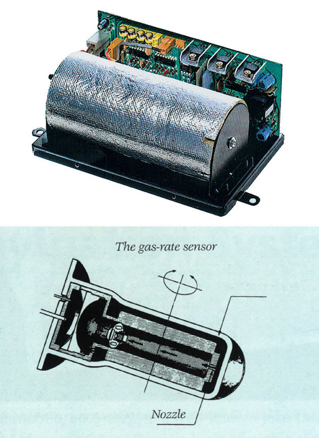
Kume had no idea of what the future would hold, but during a visit to a training site of Japan’s Self-Defense Force, he noted that a tank’s gun barrel was able to maintain sight of the target – the so-called ‘zero-target’ point – regardless how much the tank off yaws as it moves across rough terrain.

He was told this was possible by using a gyroscope device (below).

Εικόνα


Upon hearing Kume’s idea, one of Tagami’s staff suggested that a gyroscope can be adapted for a navigation system, with the ‘zero-target’ now set to the target road.

The general idea was that if a driver knows where he started from, a system that is able to continuously sum his total distance covered and the direction of travel, which should in theory able to guide a driver to his destination.

To understand how the system works, we must first drop our 2015-era understanding of how in-car navigation systems work.

This is no Waze, and it couldn’t give you turn-by-turn instructions. Remember that the required digital electronics, digital map storage and satellites were not yet available.

Instead, the concept of navigation here is closer to that used by an adventurer – you’d first have to determine your current location, plot a course on the map to your destination, and follow that course on the map.

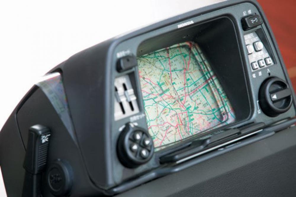
Honda’s early navigation system worked the same way. The driver pinpoints his destination on a special plastic map provided by Honda with a felt marker pen. It’s like drawing on an overhead projector’s transparency paper (remember those?).

Εικόνα


The plastic map was then fed into a system’s cathode ray tube (CRT, remember those?) screen, which has blinking dot representing the vehicle’s current position.

The driver can then drive along the plotted route, referring to the blinking dot for his current position.

Without this solution, it was impossible for a driver to read a map and drive at the same time. Honda’s system basically solves just that. The video below demonstrates how the system works.


Although initial tests showed promising results, Honda found that the system’s accuracy was highly dependent on the ambient temperature, which affected the helium gas inside the gyroscopes.

To improve the gyroscopes, Tagami approached Stanley Electric, the only company that agreed to support Honda’s project, which many thought to be a ridiculous idea to pursue.

The biggest problem faced by the team however, arose when they learnt that even if Honda succeeded in solving the gyroscope’s accuracy, the system will not be entirely accurate because of the way conventional maps are produced.

On a map of a 1:100,000 scale, a road of 10 meters wide is shown via a line only 0.1 mm thick. Clearly this is too small for anyone to read. Thus, it is impossible to do a map of an urban area by strictly following everything to scale. Some degree of freedom in altering the thin lines slightly is necessary to make the map legible. Tagami’s team learned that this practice of called ‘deformation’ is common in cartography.

It quickly became clear that to proceed further, Honda would have to assume the responsibility of producing the maps that the prototype navigation system could work with.

The fateful Suzuka To Tokyo Drive With The Boss

By early 1981, five years after Tagami was transferred from the power products team to the automotive electronics team, it was time for Tagami to demonstrate his prototype navigation system to his boss.

Tagami was to pick his boss Kume from Suzuka, where he was attending a meeting with dealers in that area, and drive him back to his house in Tokyo.

Tagami had no idea where Kume’s house was. Kume merely circled the location of his house on the map, and inserted it into the map holder in front of the CRT display fitted to the car’s dashboard.

Guiding himself with the blinking dot on the screen, Tagami navigated himself to Kume’s house, entering and exiting various highways as per the map’s guidance. When the blinking dot got nearer to the circle, Tagami stopped the car and told his boss, "I believe your house is around here."

It was a decisive moment for Tagami. After a moment of silence, Kume said "Okay, you passed the test. My house is right over there."

On August 1981, Honda introduced the Electro Gyrocator as a dealer option for the Japanese market second generation Honda Accord, which went on sale the following month. The feature was also offered for the Accord’s upmarket twin, the Japan-only Vigor.

Εικόνα

Εικόνα


Considering that the task of creating the map fell squarely on Honda, the feature was prohibitively expensive, reportedly costing a quarter of the car’s selling price. Clearly it’s not going to be a commercial success. The feature was discontinued a year later and was not introduced to other markets.

Still, Honda did not give up. Back at Honda’s Fundamental Technology Research Centre in Saitama, another researcher Yukinobu Nakamura was primed to build on Tagami’s experience and take it to the next level, by adopting digital electronics and digital maps, two new technologies now available for Honda.

The Saitama centre was the R&D centre responsible for the Asimo robot, and several other non-automotive projects. It is different from the Tochigi R&D Centre, which is primarily focused on automotive research.

Moving To Digital Maps

In 1980, just before Tagami lauched his Electro Gyrocator, Nakamura was sent by Honda to study optical-fiber gyro technology at the Electronics Engineering Research Laboratory of the Industrial Engineering Institute in the city of Gakuen.

There, he conceived the idea for a digital map-based navigation system. He still had no GPS technology to utilise.

Εικόνα

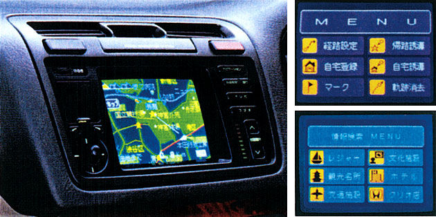
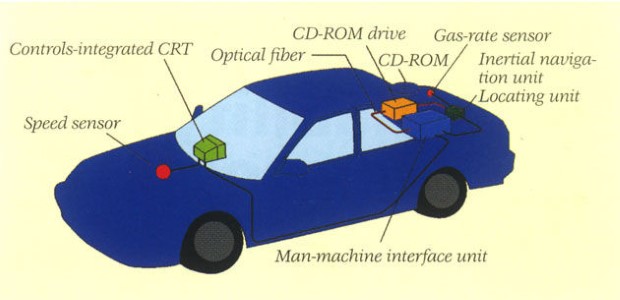
Nakamura’s system was able to do ‘map matching,’ a function which allowed the system to identify its current location simply by matching the car’s direction of travel and road patterns with the digital map. If you think about it, that’s a hugely challenging task!

Further complicating matters was Honda’s insistence that the map must be easily changed or updated by the user. Several storage mediums were explored – disks, floopy disks, microfilms, but none were suitable, so the project remained stuck in its tracks for nearly a decade.

Εικόνα


By the late ‘80s, CD-ROM technology was entering the market. The storage technology that Honda had been waiting for was now here and the project could be resumed.

In March 1988, the digital navigation system project became a joint-project between Saitama’s Fundamental Research Centre and Tochigi’s R&D Centre.

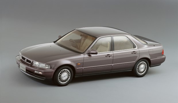
Honda’s first digital map-based navigation system was launched in 1990, as an optional feature in the Japanese-market Honda Legend (below). GPS is still not available yet.

Εικόνα


Making The Big Leap

The closest development to a present day in-car navigation system would only come in 1997 – when Honda launched its Internet-enabled Internavi service.

On 10-October 2002, a new InterNavi Premium Club system was introduced to the Japanese market Accord (similar to Accord Euro), this time with voice-operated controls for not just the GPS navigation and audio system, but also the vehicle’s air-conditioning. The driver could even dictate voice notes with it.

It could also guide the driver to the nearest and cheapest parking lot!

Εικόνα


On 17-October 2003, the new Odyssey was launched with a new HDD-based InterNavi Premium Club system that features a traffic congestion prediction function. It is the world’s first telematics system that could provide real-time traffic information, almost 10 years before anyone knew what Waze was. It was the most sophisticated telematics system in the world.

27 years after Kume told Tagami "Your role is to bring us up to the level of other manufacturers and eventually get a step ahead of them," Honda had finally attained leadership in automotive electronics.

Sadly, Honda’s InterNavi system relied on Japanese mobile communication standards and transportation infrastructure, which was well ahead of any other country. As such, the system could not be rolled out elsewhere.

The delivery of real-time traffic information for example, Honda’s InterNavi Premium Club was able to deliver such information because the Japanese government had already setup an Intelligent Transport System (ITS) initiative to monitor traffic conditions around Japan. By sending vehicle speed and GPS location data to ITS’s data processing centre, the InterNavi Premium Club system is able to show real-time traffic information to drivers.

Εικόνα


GM also had a similar service in the US, called On-Star – in fact, it was the world’s first in-car telematics system, but even in the US, there was no similar ITS data centre so GM couldn’t offer real-time traffic information (at that time).

It is only after the proliferation of smartphones and mobile Internet nearly a decade later, that third-party companies like Waze and Google were able to offer real-time traffic information.

Retrospect

Looking back, the feats achieved by engineers in the pre-Google era is hugely impressive, almost akin to building the pyramids without modern machinery.

How did they put a man on the moon (and a foldable electric car too) by working their calculus by hand on paper, or controlled rockets and launched satellites with only 4 kilobytes of computing memory and less than 1/100 the computing power of today’s smartphone?

Εικόνα


How did the folks at Honda develop a navigation system that was able to tell where you were without using GPS or triangulating signals from cellular network towers? Or one that only had printed maps to work on?

So, if you are one of those who did calculus without using a scientific calculator, and solved logarithmic and trigonometry equations with just a slide rule, and actually went to a library to complete a research paper, give yourself a pat on the back.


ΕΣΥ ΤΟΥΣ ΤΟ ΧΕΙΣ ΚΑΝΕΙ ΑΥΤΟ ALONSO MOY :s_inlove :s_shout
Άβαταρ μέλους
By MIXOStsi
#259548
Giuseppe Busso έγραψε:Καλά σήμερα είδα ένα Civic hatchback 5ης γενιάς, μπλε μεταλλικό. Σαράβαλο και χιλιοχτυπημένο μεν, γαμάτο αμάξι δε. Κουκλί ήταν. Είχε ο πατέρας μου ένα 1300 λευκό το 1992 νομίζω.


1500cc με 94bhp, sedan... :metalo:
Μετάνιωσα λίγο που το έδωσα, αλλά δεν είχα και τι να το κάνω...

Εικόνα